
Jubilee Flood Alleviation Scheme

In this December 2024 guest blog Anna Burns looks at the Jubilee Flood Alleviation Scheme.
I have worked for the Environment Agency for over 20 years and had just started my new role as Area Director for Thames Area, when flooding linked to Storm Henk began in January 2024. I saw first-hand the devastating impact that flooding can have on homes and businesses in the Thames area as well as the ongoing stress and disruption that it causes to people’s lives. I was impressed by how our teams worked with communities to warn and inform them about the risk of flooding, operated flood assets to help protect people and worked closely with councils and partners to co-ordinate our emergency response.
The Thames area is a large area of land around the non-tidal section of the River Thames and the rivers and streams that flow into it. This includes everything from the source of the Thames in Gloucestershire to the tidal limit in West London.
One of our major flood schemes in the Thames Area is the Maidenhead, Windsor and Eton Flood Alleviation Scheme. You might know it as the Jubilee River, although that is only one part of the scheme which comprises several different elements working together to reduce flood risk to around 3,000 homes in the towns and villages in the Maidenhead, Windsor and Eton area. These elements include:
• Earth embankment and control structures in North Maidenhead
• Flood walls, flood gates, raised kerbs, earth embankments and other works in Cookham
• The manmade Jubilee Flood Relief Channel which runs for over 11km alongside the Thames from Taplow to Datchet
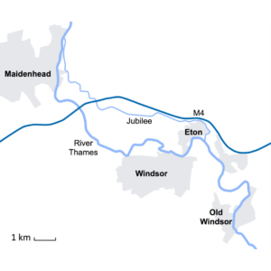
The Jubilee was designed to look like a natural river, with some water flowing through it all year round. It blends in with the surrounding landscape and has many bankside areas where wildlife can thrive. It can look inviting to swim in, but I want to emphasize that it is a flood relief channel, and it is not suitable for swimming, with sudden drops up to 5 metres deep in places making it dangerous.
When there is a risk of flooding from the Thames, we operate the Jubilee. This provides the extra space this water needs before it rejoins the Thames at Datchet. If we didn't do this, that water would flood towns and villages in the Windsor, Eton and Maidenhead areas.
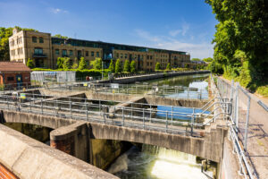
When the flow in the Thames rises to a certain level, we begin opening the gates at Taplow. We continue to make small gate movements as the flow in the Thames increases. This controls the amount of water being diverted from the River Thames into the Jubilee Channel.
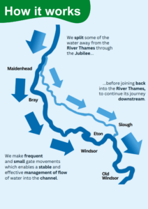
We do this in small increments, to allow flood water to flow through the Jubilee. We always control the amount of water flowing through the Jubilee. While the channel is not designed to reduce flood risk to communities upstream or downstream, it does not adversely affect them either.
As the climate changes, we are seeing more frequent and more intense rainfall, resulting in more times when flooding occurs across the Thames Valley. This means we are having to operate the Jubilee more often.
We have created a short video to illustrate how the Jubilee Flood Relief Channel works. The Jubilee Flood Relief Channel provides a case study of flood alleviation measures on a major river.
 About the author: Anna Burns has worked for the Environment Agency for over 20 years. She had just started her new role as Thames Area Director when flooding linked to Storm Henk began in January 2024. She saw first-hand the devastating impact that flooding can have on homes and businesses in the Thames area.
All images and graphics courtesy of the Environment Agency
Past guest blogs:
Past guest blogs from previous months can be found under "News: categories - past guest blogs", or by following this link https://www.geographysouthwest.co.uk/category/past-guest-blogs/